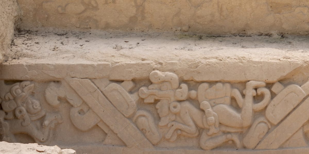

Deep in Mexico’s jungle, scientists have uncovered a complex Maya city that had been hidden for more than 1,000 years. The city, named Ocomtún, sits within the Balamkú ecological reserve in Campeche, on the Yucatán Peninsula. It includes pyramidal structures, stone columns, plazas, a ballgame court, causeways, altars, and signs of organized civic life. In other words, this was not a sleepy village with a few decorative rocks. It was a planned urban center with architecture, movement, ritual, and likely regional influence.
The discovery is exciting not only because archaeologists found another lost Maya city, but because of how they found it. Ocomtún was detected with LiDAR technology, a laser-based mapping method that can reveal shapes on the ground even when dense forest hides them from human eyes. After the laser scans suggested something important was beneath the tree canopy, researchers went into the field and confirmed the site on foot. The result is a vivid reminder that the Maya world was far larger, denser, and more sophisticated than many older maps suggested.
What Is Ocomtún?
Ocomtún means “stone column” in Yucatec Maya. Archaeologists chose the name because they found numerous cylindrical stone columns scattered across the ancient settlement. These columns likely belonged to the entrances of upper rooms in monumental buildings, giving the site one of its most memorable features. If ancient architecture had a calling card, Ocomtún’s would be: “Yes, we brought columns. Lots of them.”
The site was identified in southern Campeche, in a remote zone of the Balamkú ecological reserve. This part of the central Maya Lowlands had long been difficult to study because of thick vegetation, wetlands, limited access, and the practical problem that jungle does not politely step aside for archaeologists. The area was so little explored that researchers described it as a major blank spot on the archaeological map.
According to the findings, Ocomtún probably served as an important regional center during the Maya Classic period, roughly from A.D. 250 to 1000. Pottery recovered on the surface and in test pits appears to date especially to the Late Classic period, around A.D. 600 to 800, though further analysis is needed to refine the timeline. That makes the city part of a dynamic period when Maya communities built major centers, developed elaborate political systems, and shaped landscapes with roads, reservoirs, terraces, plazas, and temples.
How Scientists Found the Lost Maya City
The discovery began with aerial scanning. In March 2023, the National Center for Airborne Laser Mapping at the University of Houston conducted LiDAR flights over the area. LiDAR, short for Light Detection and Ranging, works by sending laser pulses from an aircraft toward the ground. The system measures how long the pulses take to return, producing a highly detailed map of the terrain.
What makes LiDAR so useful in archaeology is that it can digitally strip away the forest canopy. To the naked eye, the jungle may look like an endless green blanket. To LiDAR, that blanket becomes transparent enough to reveal unnatural shapes below: terraces, platforms, walls, mounds, roads, reservoirs, and pyramids. It is not quite X-ray vision, but for archaeologists, it is close enough to feel like a superpower.
After the laser data showed concentrations of pre-Hispanic structures, a field team led by archaeologist Ivan Šprajc entered the area in May and June 2023. The team traveled through overgrown logging paths and thick vegetation to reach the site. This was not a casual afternoon stroll with a reusable water bottle and a playlist. The journey involved remote jungle, difficult routes, and the kind of terrain that can turn a short distance into a day’s work.
Where Is the City Located?
Ocomtún lies in the Balamkú ecological reserve in Campeche, Mexico, within the broader Yucatán Peninsula. This region is part of the central Maya Lowlands, an area known for powerful ancient cities such as Calakmul and other major sites. However, the specific zone where Ocomtún was found had remained largely unknown to archaeology because it is remote, covered by medium-height tropical forest, and surrounded in places by wetlands.
The city’s monumental core sits on a raised “peninsula” of high ground amid extensive wetlands. That location matters. In a region where water, agriculture, transportation, and seasonal conditions shaped daily life, high ground could offer strategic advantages. It may have provided a stable place for monumental construction, visibility across the landscape, and access to wetland resources. The choice of location suggests careful planning rather than accidental settlement.
What Did Archaeologists Find?
The monumental core of Ocomtún covers more than 50 hectares, or about 123 acres. Within that space, researchers documented large buildings, several pyramidal structures rising more than 15 meters, three plazas, patio groups, stone columns, stairways, altars, and a ballgame court. These features point to a city with civic, ceremonial, and possibly political importance.
Pyramids and Monumental Buildings
One of the most striking discoveries is the presence of pyramid-like structures. Several rise more than 50 feet, while the most impressive construction is connected with an acropolis-like building in the northwestern part of the site. This rectangular acropolis has sides measuring about 80 meters and rises around 10 meters high. On its northern side stands a pyramid that reaches about 25 meters, or roughly 82 feet, above the natural terrain.
That kind of construction required planning, labor organization, engineering knowledge, and social authority. People had to quarry, move, shape, and assemble stone. They had to coordinate work over time. They had to feed workers and manage resources. A pyramid is not just a pile of stones with ambition. It is evidence of a society capable of organizing people around shared religious, political, or civic goals.
Three Plazas and Patio Groups
Ocomtún’s southeastern core includes three plazas dominated by imposing buildings and surrounded by patio groups. In ancient Maya cities, plazas were more than open spaces. They were gathering areas, ceremonial stages, political theaters, and social crossroads. A plaza could host rituals, announcements, markets, meetings, performances, and public displays of power.
Between two of the major plazas, archaeologists found a group of low, elongated structures arranged almost in concentric circles. This unusual layout has sparked interest because it does not neatly match every familiar Maya pattern. Some similar complexes in nearby areas may have been markets or spaces for community rituals, but researchers are careful not to overstate conclusions before more fieldwork is done.
The Ballgame Court
Ocomtún also includes a ballgame court, a classic feature of many Mesoamerican cities. The Maya ballgame was not merely a weekend sport where everyone went home with orange slices. It carried deep symbolic, political, and religious meanings. Ballcourts were places where competition, ritual, diplomacy, and cosmology could overlap.
The presence of a ballcourt strengthens the idea that Ocomtún was a meaningful regional center. Ballgames could bring people together from different communities, reinforce elite authority, and connect local life with larger Maya traditions. A city with a ballcourt was participating in one of the major cultural institutions of Mesoamerica.
Stone Columns and the City’s Name
The stone columns are among the site’s signature discoveries. Archaeologists believe many of them were probably part of entrances to upper rooms in large buildings. Their number was significant enough that researchers named the city Ocomtún, “stone column.” The columns give the site personality and help distinguish it from other Maya centers in the region.
Causeways, Altars, and Possible Market Spaces
A causeway connects the southeastern complex with the northwestern area, where the largest construction stands. Causeways were important in Maya urban planning because they shaped movement through the city. They could connect civic zones, ceremonial spaces, residential groups, and nearby settlements.
In the area extending toward the La Rigueña River, researchers found additional structures with stairways, monolithic columns, and central altars. Some complexes may have functioned as markets or spaces for communal rituals. That possibility is especially interesting because it suggests Ocomtún was not only a ceremonial center but also a place of exchange, gathering, and organized public activity.
Why the Discovery Matters
The discovery of Ocomtún matters because it changes how researchers understand settlement density and regional organization in the central Maya Lowlands. For years, some areas of Campeche appeared empty on archaeological maps. But “empty” often meant “not yet mapped,” “covered by forest,” or “too difficult to reach without expensive equipment and a patient field team.” Ocomtún shows that the absence of known sites does not equal the absence of ancient people.
The city also adds to a growing pattern. LiDAR surveys across the Maya world have revealed dense networks of settlements, roads, terraces, agricultural features, reservoirs, and urban centers. These discoveries challenge older views of the Maya as scattered groups living in isolated pockets. Instead, the evidence points to complex landscapes filled with communities that engineered their environment and interacted across wide regions.
Ocomtún also helps researchers compare nearby sites such as Nadzcaan, Chactún, and other centers in the Chenes region. Its position may show how political and ceremonial centers were distributed across Campeche. If future excavations uncover inscriptions, burials, household remains, or more precise ceramic sequences, scholars may be able to understand who lived there, how long the city flourished, and what role it played in regional networks.
What the City Reveals About Maya Urban Planning
Ocomtún’s layout suggests a city designed around elevation, plazas, monumental architecture, and movement. The high-ground setting amid wetlands was likely no accident. Ancient Maya builders understood terrain and water. They often placed cities where natural features could be adapted into urban systems.
The presence of plazas points to public life. The causeway points to organized movement. The ballcourt points to ritual and political culture. The acropolis and pyramids point to authority and ceremony. The possible markets or communal ritual spaces point to everyday interaction. Together, these features show a city that was both symbolic and practical.
That combination is one reason Maya cities fascinate archaeologists. They were not simply collections of temples. They were lived-in landscapes where farming, governance, religion, family life, astronomy, trade, and art all intersected. A pyramid might express divine power, but someone still had to haul water, prepare food, tend crops, raise children, repair buildings, and complain about the weather. Ancient cities were grand, but they were also human.
What Happened to Ocomtún?
Researchers believe Ocomtún underwent changes during the Terminal Classic period, around A.D. 800 to 1000. Archaeologists found signs that some later shrines were built in the centers of patios and small plazas using materials taken from nearby buildings. This may reflect ideological and population changes during a period of crisis.
Across parts of the central Maya Lowlands, many cities experienced political breakdown, demographic decline, drought stress, conflict, shifting trade routes, or combinations of several pressures. The so-called “Maya collapse” was not one single event, and it did not mean Maya people vanished. Maya communities continued, adapted, migrated, and remain alive today. But many Classic-period cities lost population and political power by the 10th century.
Ocomtún appears to fit within that wider regional transformation. Its decline may help scholars understand how major centers responded to stress. Did people leave gradually? Did rituals change first? Did elites lose authority? Did nearby communities absorb the population? These are the kinds of questions future excavations may help answer.
LiDAR: The Technology Turning Jungle Into Evidence
The Ocomtún discovery is part of a larger archaeological revolution driven by LiDAR. Traditional jungle archaeology can be slow and physically demanding. Researchers walk through dense vegetation, identify mounds, clear small areas, map features, and compare what they see on the ground with known architectural patterns. This work remains essential, but LiDAR changes the starting point.
Instead of wandering blindly through forest, archaeologists can use laser maps to identify promising locations before entering the field. LiDAR does not replace excavation or expert interpretation. It can reveal shapes, but it cannot automatically explain who built them, when they were used, or what happened there. Think of it as the world’s most dramatic treasure map, except the “X” is a suspicious rectangle under a billion leaves.
Once researchers have the map, they still need field verification. They must walk the site, examine ceramics, measure structures, document architecture, and test hypotheses. Ocomtún is a perfect example of technology and traditional archaeology working together: lasers found the possibility; human expertise confirmed the city.
Specific Examples That Show Ocomtún Was Complex
Several details make Ocomtún stand out. First, the monumental core covers more than 50 hectares, which is large enough to suggest substantial planning. Second, the city contains multiple plazas and patio groups, showing organized public and residential space. Third, the acropolis and pyramid indicate major construction investment. Fourth, the ballcourt links the city to broader Mesoamerican ritual traditions. Fifth, the causeway shows structured movement between city sectors. Sixth, the columns and altars point to distinctive architectural and ceremonial practices.
These features are not random. Together, they suggest that Ocomtún was a regional hub where people gathered, traded, worshiped, governed, and performed community rituals. Even without a full excavation, the visible architecture already tells a story of complexity.
Experience Section: What This Discovery Feels Like From the Jungle Floor
To understand why the discovery of Ocomtún feels so powerful, imagine standing at the edge of the Balamkú forest before sunrise. The air is heavy, the ground is uneven, and every sound seems amplified: insects buzzing, birds calling, leaves shifting, branches cracking somewhere in the green distance. The modern world quickly feels far away. Your phone may still have a camera, but the jungle has better reception with the past.
Now imagine walking for hours through vegetation so dense that every meter has to be earned. A hill that looked simple on a LiDAR map becomes a steep, tangled rise. A clean rectangle on a screen becomes a mound hidden under roots, vines, and soil. Then, suddenly, you see it: a shaped stone, a stairway line, a column lying where no natural column should be. The moment is quiet but electric. It is the feeling of realizing that the forest has not been empty at all. It has been guarding a city.
For the researchers, the experience likely combined excitement with caution. A discovery like Ocomtún is thrilling, but archaeology is not a movie montage where someone brushes dust from a golden idol and dramatic music immediately plays. Real fieldwork means careful recording, patient measurement, context, and restraint. Every stone must be understood before it becomes a headline. Every interpretation has to survive evidence.
For readers, Ocomtún offers another kind of experience: the thrill of mental travel. Even if you never hike into Campeche, the discovery lets you picture a Classic Maya city alive with movement. People cross the causeway. Vendors gather near public spaces. A ballgame draws a crowd. Smoke rises from households. Leaders stand in elevated rooms supported by stone columns. Ceremonies unfold in plazas. Children run between patio groups, probably ignoring someone telling them not to climb on things. Some human behaviors are timeless.
The discovery also changes how we experience maps. A blank space on a map can feel like emptiness, but Ocomtún teaches that blank spaces may simply be places we have not learned how to read. With LiDAR, researchers are learning to read the jungle differently. Hills become platforms. Lines become causeways. Clusters become neighborhoods. The forest becomes an archive.
There is also an emotional lesson here. Ocomtún reminds us that history is not finished. Even in a world of satellites, drones, databases, and endless online scrolling, there are still cities waiting under trees. That thought is wonderfully humbling. The past is not a closed book on a dusty shelf. Sometimes it is a 123-acre city under the jungle, quietly waiting for lasers, patience, and a team willing to walk into the green unknown.
Conclusion
The discovery of Ocomtún is one of those archaeological stories that feels almost too cinematic to be real: a hidden Maya city, deep jungle, laser mapping, pyramids, columns, plazas, and a ballcourt. But beyond the adventure, the discovery has serious scholarly value. It shows that the central Maya Lowlands were more densely and creatively occupied than many older maps suggested. It also proves that technology works best when paired with field expertise, local knowledge, and careful interpretation.
Ocomtún was not just a collection of ruins. It was a city with structure, movement, ritual, and regional significance. Its pyramids and plazas speak to political and ceremonial life. Its columns give the site a distinctive identity. Its causeways, altars, and possible market spaces hint at a busy public world. And its decline during the Terminal Classic period may help researchers better understand one of the most important transformations in ancient Maya history.
In the end, the most exciting detail may be this: Ocomtún was hidden, but not gone. The jungle covered it, time softened it, and modern maps missed it. Then lasers revealed its shape, archaeologists confirmed its presence, and an ancient city reentered the story of the Maya world. Not bad for a place that spent more than a millennium keeping a very impressive secret.