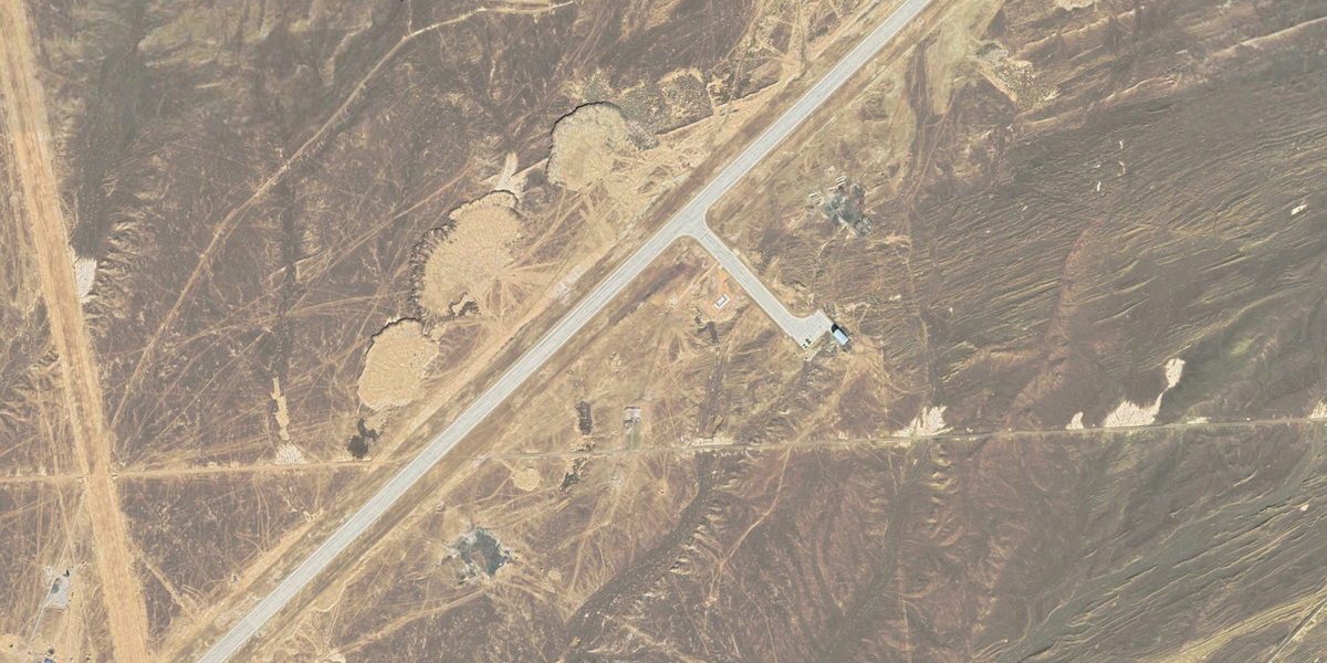

Some places on Earth seem designed to make map nerds squint. A lonely desert runway. A few sharp-edged hangars. Fresh aprons appearing where there used to be sand. Aircraft shapes that look less like planes and more like someone lost a bet with geometry. That is why a remote Chinese airfield near Lop Nur in Xinjiang has earned an irresistible nickname: “China’s Area 51.”
The phrase is catchy, but it can also be misleading. Area 51 is not famous simply because it is secret. It became legendary because it combined isolation, experimental aircraft, restricted airspace, Cold War mystery, and decades of public speculation. The Chinese site now attracting attention shares some of those ingredients. Satellite images show a huge runway, new construction, unusual aircraft activity, and a location near China’s historic nuclear test grounds. In other words, it has all the scenery of a spy thrillerminus the background music and the guy in sunglasses saying, “You didn’t see anything.”
So, is China building an Area 51? The best answer is: not exactly, but it appears to be expanding a highly secretive aerospace and military testing complex that performs some Area 51-like functions. Satellite images do not prove everything. They do not reveal classified intentions, engineering performance, or what happens inside the hangars. But they do show patterns, and the pattern is hard to ignore: China is investing heavily in remote test infrastructure for advanced aircraft, drones, spaceplanes, and possibly systems connected to nuclear modernization.
Why People Compare the Site to Area 51
America’s Area 51, located at Groom Lake in Nevada, became famous as the home of secret flight testing for aircraft such as the U-2 and A-12. Its value was simple: put experimental machines somewhere far from curious eyes, give pilots a dry lakebed and restricted airspace, and keep the public guessing for the next half-century. A perfect recipe, reallyequal parts engineering lab, desert bunker, and conspiracy magnet.
The Chinese facility near Lop Nur checks several similar boxes. It sits in a remote desert region far from major cities. It has a runway reportedly longer than three miles, large enough for unusual aerospace testing. It is connected in public analysis to China’s reusable spaceplane activity. And in recent years, commercial satellite imagery has shown expanding support buildings, new hangars, larger aprons, and aircraft that appear to belong to China’s next generation of airpower.
The comparison is not about UFO folklore. It is about function. Area 51 was a controlled environment for testing technologies before the public was supposed to know much about them. China’s Lop Nur-area airfield appears to serve a similar purpose: testing things Beijing would prefer to discuss only when Beijing is ready.
What Satellite Images Actually Show
The earliest wave of public attention came in 2021, when satellite images showed new construction near a massive remote runway in western China. Reports described around a dozen large concrete buildings rising near the landing strip, a meaningful change for a site that had previously appeared sparse. Analysts suggested the facility could be important to China’s military space activities, especially because China had reportedly used the location in 2020 for the landing of a classified reusable spacecraft.
That alone would have made the airfield interesting. But later imagery made it much more interesting. By 2025, commercial satellite images showed major expansion at the site, including apron enlargement and new hangars. More dramatically, Planet Labs imagery reported by defense analysts appeared to show two advanced Chinese tailless stealth aircraft designscommonly called the J-36 and J-XDS or J-50at the remote base. These aircraft had previously been associated with their manufacturer airfields, so seeing them at a desert test base suggested the facility was becoming more central to advanced flight evaluation.
One of the aircraft, the J-36, has been described as a large, three-engine, tailless design with a broad delta-like planform. The other, often called J-XDS or J-50, appears smaller but still falls into the heavy fighter category. Because these observations come from overhead imagery, every measurement and role assessment comes with a caution label. Satellite photos can measure wingspan better than they can read a mission planner’s mind.
The Runway Is a Clue, Not a Conclusion
A runway longer than 16,000 feet is not built for your average commuter flight. Long runways are useful for heavy aircraft, high-speed testing, emergency margins, spaceplane recovery, and unusual experimental vehicles. At Lop Nur, the runway’s size is one of the strongest visual clues that the site was designed for more than routine fighter operations.
That does not mean every aircraft there is a spaceplane or secret bomber. Big runways can support multiple missions. They can provide safety margins for prototypes that behave unpredictably. They can handle aircraft with unusual landing speeds. They can also help test vehicles that return from high-altitude or orbital missions. In aerospace testing, extra runway is like extra coffee during tax season: nobody complains when things get tense.
The airfield’s isolation also matters. Remote test sites reduce the chance of casual observation, make it easier to control access, and allow flight profiles that would be difficult near populated areas. In the United States, the Nevada desert served that role. In China, the deserts of Xinjiang offer similar geographic advantages.
Why Lop Nur Matters
Lop Nur is not just a random empty place on a map. It is historically significant because it was the area where China conducted nuclear tests during the Cold War. That history makes every new tunnel, borehole, road, support building, or restricted facility in the region more sensitive than it might otherwise be.
Recent reporting and think-tank analysis have pointed to expanded activity at the broader Lop Nur nuclear test site, including new tunnels, vertical shafts, support infrastructure, and signs of renewed readiness. Analysts disagree on what exactly the activity means. Some view it as preparation for possible future tests, including lower-yield or subcritical experiments. Others caution that imagery alone cannot prove that a nuclear test has occurred or will occur.
That distinction matters. Satellite images are powerful, but they are not magic. A tunnel entrance may suggest preparation. A drill site may suggest a future test capability. A support building may suggest increased personnel or equipment. None of those details automatically proves an imminent nuclear detonation. Good analysis lives in the uncomfortable middle: suspicious enough to matter, not certain enough to sensationalize.
China’s Broader Aerospace Puzzle
The Lop Nur-area base is only one piece of a larger Chinese military modernization picture. Satellite imagery has also revealed unusual activity at other Chinese test sites, including Malan, another secretive facility in Xinjiang associated with unmanned aircraft development. Images from recent years have shown large flying-wing drone designs, stealthy unmanned combat aircraft, and aircraft that resemble high-altitude long-endurance platforms.
BlackSky imagery also captured what analysts described as an alleged airship at the Korla East Test Site in 2022. That image stood out because it suggested Chinese interest in high-altitude or persistent surveillance platforms. Add that to stealth drones, tailless fighters, reusable spaceplanes, and expanded desert infrastructure, and the trend becomes clearer: China is not building one mysterious base; it is building an ecosystem.
That ecosystem appears designed to support the next generation of military aviation and space technology. The main ingredients are secrecy, distance, long runways, hangars sized for unusual aircraft, and access to controlled airspace. It is not one “Area 51” so much as a network of test ranges, airfields, laboratories, and launch or recovery sites. Less Hollywood, perhaps, but far more strategically important.
What the J-36 and J-XDS Sightings Could Mean
The reported appearances of the J-36 and J-XDS at the Lop Nur-area base are among the most eye-catching clues. Advanced tailless aircraft are often associated with reduced radar signatures, long-range missions, sensor fusion, and future air combat concepts. The J-36’s large size has led some analysts to speculate that it may be designed for extended range, heavy payloads, command-and-control functions, or coordination with drones. The J-XDS appears to represent another branch of China’s next-generation fighter development.
Still, the word “could” is doing a lot of honest work here. A prototype on a runway does not tell us whether the program is mature, whether the aircraft meets its goals, or whether it will enter production. Many experimental aircraft look terrifying in photographs and then quietly retire into the museum of “interesting ideas that were expensive.” But the fact that China has multiple advanced designs appearing in public imagery suggests a serious development push.
The key takeaway is not that China has already surpassed the United States in sixth-generation airpower. The key takeaway is that China is moving fast, testing visibly enough for commercial satellites to notice, and investing in infrastructure that supports long-term experimentation.
Why Commercial Satellites Changed the Game
During the original Cold War, secret bases could remain mostly secret because only governments had regular access to high-quality overhead imagery. Today, commercial satellite companies collect frequent images of strategic locations around the world. Analysts, journalists, and independent researchers can compare images over time, identify new construction, measure aircraft, and track activity patterns.
This does not eliminate secrecy. Hangars still hide aircraft. Underground facilities still hide equipment. Camouflage, decoys, timing, and operational discipline still matter. But the age of perfect invisibility is over. When a new aircraft sits outside in daylight, there is a decent chance a satellite will eventually catch it photobombing geopolitics.
China knows this. That raises an interesting question: are some of these exposures accidental, or are they toleratedeven encouragedas strategic signaling? Showing a mysterious aircraft without explaining it can create buzz, uncertainty, and deterrent value. Sometimes a blurry satellite image can be more useful than a polished press release.
What the Images Do Not Show
Satellite images can show concrete, shadows, aircraft outlines, roads, tunnels, vehicles, and construction tempo. They cannot show software quality, engine reliability, radar performance, pilot training, command doctrine, or manufacturing bottlenecks. Those hidden factors often matter more than the dramatic shape of an aircraft.
For example, a tailless stealth fighter may look futuristic from orbit, but its real value depends on engines, sensors, materials, weapons integration, maintenance, data links, and the doctrine around it. A huge runway may support spaceplane testing, but imagery alone cannot confirm the full mission. A new tunnel at a nuclear site may indicate readiness, but it does not prove a nuclear explosion occurred.
That is why responsible satellite analysis uses careful language: “appears,” “suggests,” “likely,” “possible,” and “consistent with.” These words are not weakness. They are the seatbelts that keep analysis from flying through the windshield.
Is China Building an Area 51?
China appears to be building, expanding, and modernizing facilities that resemble Area 51 in purpose: remote testing of highly sensitive aerospace and military technologies. The Lop Nur-area airfield is the clearest example because of its runway, expansion, possible spaceplane connection, and reported sightings of next-generation stealth aircraft. But the better way to frame it is this: China is building an Area 51-style capability, not simply copying Area 51 as a single location.
The difference matters. The U.S. Area 51 legend grew around one famous place. China’s approach appears distributed across several sites, each supporting a piece of the modernization puzzle. Lop Nur may support spaceplane and advanced aircraft work. Malan appears tied to unmanned aircraft and stealth drones. Korla East may relate to airship or high-altitude surveillance experimentation. Other facilities, including laser fusion and nuclear support sites, add another layer to the strategic picture.
So yes, in the broad sense, China is building something Area 51-like. But no, it is not just a desert runway with a spooky nickname. It is part of a larger military-industrial transformation.
Why This Matters for the United States and Its Allies
The significance of these satellite images is not merely that China has secret toys in the desert. The real issue is timing. China is modernizing its air force, expanding its nuclear forces, developing unmanned systems, improving space capabilities, and building infrastructure to test all of it. These efforts could affect future military balances in the Indo-Pacific, especially around Taiwan, the South China Sea, and long-range strike operations.
For the United States and its allies, the images are a reminder that military competition is no longer limited to aircraft carriers and missile counts. It includes test ranges, prototype cycles, drone autonomy, satellite surveillance, hypersonic research, nuclear command systems, and the ability to turn experimental technology into operational units.
At the same time, alarmism helps no one. A satellite photo is not a war plan. A prototype is not a squadron. A tunnel is not automatically a test. The smart response is sustained monitoring, better analysis, arms-control engagement where possible, and realistic investment in deterrence and transparency. Panic is a poor analyst. It also tends to make terrible coffee.
Experience Section: What It Feels Like to Study a Secret Base From Space
Looking at a suspected secret base through satellite images is a strange experience because it feels both powerful and incomplete. On one hand, you can zoom into a place that almost no ordinary person will ever visit. You can watch roads appear, hangars grow, aircraft move, and construction spread across an empty landscape. On the other hand, you are always aware that the most important details are hidden. The image gives you the stage, not the script.
The first experience is usually confusion. A desert airfield looks simple until you start comparing images over time. One week, there is a scraped patch of land. Months later, it becomes a taxiway. Then a hangar appears. Then the apron expands. Then a strange aircraft shape appears near a building, and suddenly the empty desert feels like a chessboard. Every shadow becomes suspicious. Every vehicle looks important. Even a pile of dirt starts acting like it has classified clearance.
The second experience is humility. It is tempting to turn every unusual object into a dramatic conclusion. A white shape at the end of a runway becomes a secret vehicle. A new tunnel becomes proof of testing. A large hangar becomes evidence of a bomber. But good open-source intelligence is not about guessing loudly. It is about comparing, measuring, checking dates, reviewing past imagery, and asking what alternative explanations could fit the same facts.
The third experience is appreciation for time. One satellite image is a snapshot. Ten images become a story. A base may not reveal its purpose in a single frame, but construction tempo can be revealing. If new buildings appear quickly, roads are improved, aprons are widened, and aircraft begin showing up, the site is becoming more active. That pattern is often more meaningful than one dramatic image.
The fourth experience is realizing that secrecy has changed. During the Cold War, secret aircraft programs could stay hidden for years because overhead imagery was mostly controlled by governments. Today, commercial satellites create a kind of global observation layer. States can still hide a lot, but they must assume they are being watched. That changes behavior. It may push more activity indoors. It may also encourage selective exposure, where a country lets the world glimpse just enough to create uncertainty.
The final experience is balance. The Lop Nur-area airfield is fascinating, but fascination should not become fantasy. Satellite images show that China is expanding a remote, sensitive test facility and using it in ways consistent with advanced aerospace development. They do not show aliens, magic weapons, or guaranteed military dominance. The truth is more serious and more interesting: modern power is being built in deserts, behind hangar doors, under satellite paths, one concrete pad at a time.
Conclusion
China’s suspected “Area 51” is not a copy-paste version of America’s famous Groom Lake facility. It is better understood as part of a growing network of Chinese test sites designed for advanced aircraft, drones, space systems, and strategic military research. Satellite images show a remote airfield near Lop Nur with a very long runway, expanding infrastructure, new hangars, and reported sightings of next-generation stealth aircraft. Nearby nuclear-site activity adds another layer of concern, though imagery alone cannot prove secret nuclear testing or future intent.
The most important lesson is not that one mysterious base exists. It is that commercial satellites are revealing how quickly China is building the physical infrastructure needed for future military competition. The desert is no longer empty. It is becoming a laboratory, a runway, a signal, and a warning label all at once.